Your Cart is Empty
English


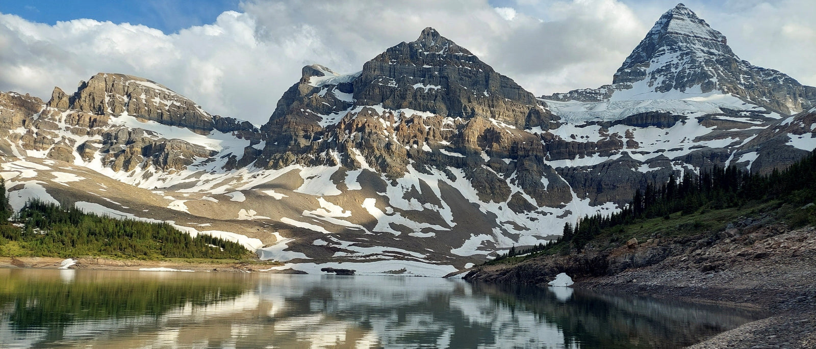
Mount Assiniboine rises sharply from the heart of the Continental Divide – the long ridge of the Rocky Mountains which separates the watershed of the Pacific Ocean from those of the Atlantic and Arctic Oceans. Known as ‘Canada’s Matterhorn’ due to its distinctive pyramidal shape, the mountain presides over a myriad of alpine meadows, expansive pine forests and glacial blue lakes.
It also gives its name to the larger Mount Assiniboine Provincial Park. This is part of the Canadian Rocky Mountain Parks UNESCO World Heritage Site, designated for its unique scenery and geological features. Without any roads, there are only a few ways to access the park: on foot, horse, bicycle or by helicopter. However, its multitude of campgrounds and network of trails, in addition to its proximity to neighbouring Banff and Kootenay National Parks, makes Assiniboine Provincial Park the perfect introduction to the Canadian backcountry.

One of the park’s most popular hikes is the multi-day trek up Assiniboine Pass to the picturesque Lake Magog, and back down Wonder Pass. The hike can be completed over two or three days, although many choose to extend it to four or five days to make the most of the scenery. This comprehensive first-hand guide provides a detailed account of the journey, in addition to tips and tricks for those wishing to complete the Wonder Pass loop for themselves.
Note: Mount Assiniboine Provincial Park is located within the traditional territory of the Ktunaxa First Nations people. We recognise the significance of this area to indigenous people and express gratitude for their stewardship of the land.
Mid-June in the Canadian Rockies is a time of transition. Snow still coats the highest tops and nestles in the cirques (steep-sided valleys, the Canadian version of a ‘corrie’), while the first flowers bloom in the alpine meadows below. At the Mount Shark trailhead, where our journey began, we were greeted with gentle sunshine and t-shirt weather, although our packs were heavily weighted with the fleeces, down jackets and down sleeping bags that we would soon need.
The Mount Shark trailhead lies in the northern part of what is known as ‘Kanaskis Country’ – an expansive area known for its rugged wilderness and varied landscapes. This is where our group of seven gathered on the first morning, passing introductions between those that hadn’t met before and comparing pack weights. I was pleased to find that mine was only the joint second heaviest – at least two people would be suffering as much as me!

The first section of trail followed a wide forestry track lined on either side with wild strawberries, purple heather and yellow-tongued calypso orchids; past the green hues of Watridge Lake peeking shyly through the pine trees. Stopping for lunch beside the icy rapids of the Spray River, we marveled at the twisting spire of Cone Mountain rising up in the distance whilst butterflies flitted amongst the flowers surrounding us.

As we set off again, an Arctic blue butterfly chose to catch a ride on my nose for the next kilometre, and another nestled in my friend’s hair. We crossed Bryant Creek – which we would be following for the next 24 hours – and joined the Great Divide Trail. This long-distance trail traverses the continental divide up the Canadian Rockies between the provinces of British Columbia and Alberta for over 1,100km, passing Mount Assiniboine over the Wonder Pass.

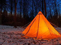
Further winding trails through the pine forest brought us to BR14, our campsite for the night. At only 14km from the trailhead, this was essentially a ‘half-day’ of walking which provided enough time in the afternoon for us to explore the local area. We occupied ourselves by pitching tents, scrambling up a nearby waterfall, paddling in Bryant Creek, admiring an enormous pair of moose antlers and doing yoga in the meadows. Nestled in the valley with the surrounding peaks dripping in the alpenglow of the setting sun, this part of the Canadian backcountry felt totally serene.
The next morning greeted us with a blanket of rain clouds. It didn’t take long to pack up the tents and eat breakfast, which is when I discovered that the foam handle of my carbon fibre walking pole had been gnawed by a hungry marmot during the night. I suppose that’s what happens when you ignore the signs around camp warning visitors of the marmots’ insatiable appetite! Lesson learnt: don’t leave anything outside of the tent in the Rockies.

Before long we were once again marching through pine trees, following Bryant Creek upstream. The tall crags brooding on either side of the valley seemed especially foreboding as dark clouds gathered overhead and a thunderstorm rolled in. Thunder reverberated from the rocks to our bones while we hunkered down and waited for the storm to pass.

Within half an hour the sun was peering down at us again, glistening off rain drops on the surrounding vegetation. We ate lunch on a bridge crossing a bubbling creek lined with willows, before pressing on up the steep ascent of Assiniboine Pass leading to the border between Alberta and British Columbia, alongside the boundary between Banff National Park and Assiniboine Provincial Park.

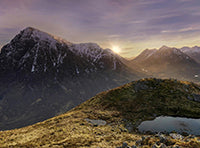
This is where the truly impressive scenery began. We received our first sighting of Mount Assiniboine rising out of the forest as we crossed a series of high alpine meadows glittering white and yellow with western anemones and white mountain avens. She was a shark fin spearing into the sky, and if I didn’t know better, I could have easily mistaken her for the Matterhorn. For a while we burst into song, until our energy levels began to wane and the group fell into a more subdued silence. Such is the nature of long-distance trekking: not every minute is spectacular, but even in the quiet and fatigued ones, you’ve got to keep putting one foot in front of the other. There is great comfort to be found in consistency.

Spirits lightened again once our destination of Lake Magog came into view. Snow-flecked mountains framed the slate-blue water, and a pair of bald eagles soared above us in welcome. This is where the real attraction of trekking in mid-June became clear: whereas in July and August the Lake Magog campsite is entirely booked out, we had it entirely to ourselves. To reach the campground we crossed a few lingering banks of snow – some more than knee deep – and indulged in a short snowball fight. Throwing snowballs three days before the summer solstice felt odd to me as a Brit, but that’s what life in the Canadian Rockies is like! After pitching our tents, we wandered down to Lake Magog for an icy dip. As the snow meltwater chilled our bones, we mused that we felt similarly to the early alpine flowers blooming around us: as if we were waking up for the first time after a very long sleep.

Although our third day began with gentle sunshine and blue skies, a weather update on our Garmin InReach suggested that the conditions wouldn’t last. Our original plan was to walk over the Wonder Pass to the BR13 campground. However, this would mean packing up and walking back the next morning in torrential rain. We were feeling good enough to walk a longer distance, and three of our members had a leaky tent that had already proved to be inadequate protection against the thunderstorms, so we decided to try to press on for around 28km back to the Mount Shark trailhead. As mountain meadows gave way to the light green of spring larch in spring (June is still springtime in the Rockies), we began the steep incline to the top of the Wonder Pass.

The section that followed, from the top of Wonder Pass to the Bryant Creek area, was without a doubt one of the most stunning sections of trail I have ever walked along, second only to the Seven Lakes trail in Slovenia. Streams and waterfalls raced down the crags either side, making the area much greener than most of the Rockies, as the path curved through a bright yellow sea of glacier lilies. Descending into the pine forest towards the teal blue of Marvel Lake, we may as well have been heading towards Rivendell. We traversed along the length of Marvel Lake for the next few kilometres, through purple swathes of silky phacelia and red blankets of Indian paintbrush.

By the time we reached BR13, where we stopped for some food, we were all feeling a little worse for wear. Several of us had blisters, all of us had aching backs, and one of us had heatstroke. The rest of the journey back to the trailhead felt like a bit of a slog, made more tolerable with a hipflask of amaretto that we passed around.

It was satisfying to arrive back at the trailhead and see dark storm clouds building up on the horizon, moving a little too slow to catch up with us. We were fatigued and yet content, having spent an incredible three days in the Canadian backcountry, walking through snow, storms and sunshine in expansive wilderness. The Wonder Pass loop had been an unforgettable introduction to multi-day trekking in the backcountry, with its medley of different habitats and abundance of incredible views.
Planning a multi-day trek through Mount Assiniboine Provincial Park requires careful preparation, from securing campground bookings months in advance to packing for unpredictable mountain weather. These essential tips will help you make the most of your Wonder Pass Loop adventure while staying safe in Canada's spectacular backcountry wilderness.
The circuit is most popular during the summer months (July and August). During this time, Assiniboine Lodge is also open near Lake Magog, a backcountry hut providing food and accommodation. Late July and early August are particularly good times to see the alpine wildflowers, and to cross the Wonder Pass without snow. However, these are also the busiest months. Campgrounds get booked up early in advance and it is more difficult to get a real sense of isolation. Outside of the main tourist season, June is perfect for quiet campgrounds and early alpine flowers, but brings a higher risk of the pass still being blocked by snow. September is also quieter, and the alpine is especially beautiful during the time known as ‘larch season’, when the larch trees coat the hillsides in gold.

Although we ended up doing the trek in three days, we’d originally planned to complete it in four. It can even be done in two days with a night at Lake Magog in between. However, three or four days provide more time to explore and appreciate the area. There are several campgrounds along Bryant Creek with varying distances from the trailhead, which also allow for a half day on the first and/or final day of the trek.
Booking for the Lake Magog campground is found on the BC Parks website, while booking for the other campgrounds is through Parks Canada. You will also need to book a backcountry permit and a Kananaskis Conservation Pass to drive up Spray Lakes road and park at the Mount Shark trailhead.
There are a multitude of options for extended forays into Assiniboine Provincial Park. From Lake Magog campground, The Niblet, The Nublet, and Sunburst Peak are all popular mountains that can usually be done in a half-day. Longer, more technical additions include the Marvel Peak traverse, or any of the summits from the R.C. Hind Hut (which requires a glacier crossing to reach), including mighty Mount Assiniboine itself.
The circuit through Assiniboine Pass and Wonder Pass is probably the most popular hike to Lake Magog, but an alternative route from Sunshine Meadows (near Banff) is equally beautiful. It is possible to get public transport to the Sunshine Meadows trailhead, but not to the Mount Shark trailhead. Those preferring a thru-hike might choose to walk from Sunshine Meadows to Mount Shark via the Wonder Pass (or vice versa) to see as much of the area as possible.
The provincial park is a critical grizzly bear habitat, with several female grizzlies raising cubs there. As a result, certain areas have restricted use in August and September, and visitors are legally required to travel in tight groups of four or more. Check the Parks Canada website for updates on trail restrictions.
 |
 |