Your Cart is Empty
English


Standing sentinel on forbidding clifftops, rocky promontories and jutting headlands, Britain’s lighthouses kept sailors safe from harm for centuries. These towering structures, built in rugged, remote and often lonely locations, make for prominent landmarks with a unique appeal that are a highlight of any coastal walk.
‘The red-and-white striped lighthouse at Beachy Head is easy to pick out against the chalky white cliffs. It is an iconic sight that has appeared almost everywhere, from vintage postcards to Bond films.’

The stretch of coastline between the Rivers Tyne and Wear is one of the most treacherous parts of Britain’s coast. That’s why you pass so many lighthouses when walking along the coast path from Roker Pier in Sunderland to Whitley Bay in North Tyneside. The lights were constructed to help guide ships away from hazardous rocks and shoals on their way into and out of these two great rivers.
From Roker Pier, head along the coastal path, passing the iron lighthouse in Roker Cliff Park. Stick to the path to visit Souter Lighthouse, the world’s first purpose-built electric lighthouse. Continue through South Shields to catch the Tyne ferry to North Shields. From Fish Quay, it’s an easy route along the coast to reach St Mary’s lighthouse, north of Whitley Bay. Perhaps the most impressive of all, St Mary’s stands on a very small island, which can be reached at low tide via a causeway.

Rattray Head lighthouse was built in 1895 by the engineers and brothers David and Charles Stevenson, at the behest of the Northern Lighthouse Board. The project was backed by numerous ship owners, who had clamoured for a light on this notorious stretch of coast for years. Surrounded by the golden dunes of Rattray Head Beach, it is a photographer’s dream, especially at high tide when the lighthouse becomes entirely cut off from land.
Start out at St Combes and head along the vast beach towards Rattray. You’ll need to detour inland slightly to avoid a lagoon, passing over a bridge near the Loch of Strathbeg, Britain’s largest dune loch. Walk between the loch and the beach, keeping a look out for wildlife. Follow the beach until you reach Rattray Head and the lighthouse.

The rocky outcrop of Strumble Head on the Pembrokeshire coast is well-known not just for its lighthouse, but also for its wildlife. The lighthouse itself is perched on a tiny island just off the coast, linked to the mainland via a suspension bridge. The birdlife is perched just about everywhere, from sooty shearwaters to arctic skuas. It’s not unusual to catch a glimpse of harbour porpoises and grey seals either, and if you’re really lucky, you might spot dolphins and orcas.
From Gawn Fawr car park, turn right onto the road, looking out for a path on the right that skirts around the hillfort. Cross a road and turn right onto the coast path. Follow the path all the way to Strumble Head.

The red-and-white striped lighthouse at Beachy Head is easy to pick out against the chalky white cliffs of the Sussex coast. It is a spectacular sight that has become an icon of Britain, appearing in everything from vintage postcards to Bond films. This walk also takes you past the Belle Tout lighthouse, now a B&B, as well as giving great views out over Beachy Head.
Start from the car park at Birling Gap and look for the red phone box. From here a signed footpath takes you to the coast path. Follow the coast path to the left, making sure you don’t stray too close to the edge. Pass Belle Tout lighthouse and carry on along the South Downs Way to reach Beachy Head. Take your time to enjoy views out over Beachy Head lighthouse before retracing your steps to the start.

Rugged Lundy Island lies at the mouth of the Bristol Channel. More than 200 shipwrecks have been recorded along this part of the coast, which is why Lundy has two lighthouses in operation – Lundy South and Lundy North. They replaced the original lighthouse, now known as the Old Light, which was built on the summit of Chapel Hill in 1819, but wasn’t deemed sufficient to keep sailors safe. It has now been converted into accommodation for visitors seeking a unique stay.
Take the boat to Lundy, which drops you at Landing Bay. From here, follow the track up the hill to reach the centre of the village. Pass farm buildings and turn left on a path through a field. Keep heading towards the old lighthouse, which you pass to reach the coastal path around the island. Take a slight detour here towards Lundy South Lighthouse, before retracing your steps and turn left onto the coast path to circumnavigate the whole island. You’ll reach Lundy North Lighthouse at the top of the island, which seems to perch precariously on a narrow plateau of rock.

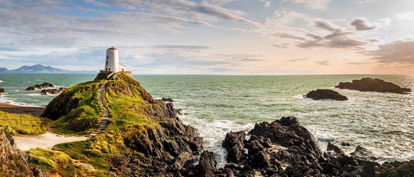
Ynys Llanddwyn is a small islet set among a landscape of rolling dunes and rocky outcrops. You’ll find it off the coast of the much larger island of Ynys Môn, better known in England as Anglesey, in North Wales. As well as Twr Mawr lighthouse, built in 1845 and modelled on traditional local windmills, this magical place also boasts a smaller lighthouse – Twr Bach – and the remains of an ancient church dedicated to Wales’ patron saint of lovers.
Start from Llyn Rhos Ddu car park and either walk out along the beach or through Newborough Forest, one of the largest publicly accessible forests in Wales, which is an important habitat for red squirrels. Emerge close to Ynys Llanddwyn, which despite its name is really a narrow finger of land. This means it usually remains accessible except at very high tide. It’s home to the two 19th-century lighthouses of Twr Mawr and Twr Bach, which stand at the island’s tip, alongside two restored pilot’s cottages. The men who lived here would row out to help ships negotiate the treacherous sandbars between Caernarfon and Abermenai point, as well as manning the local lifeboat. Don’t forget to visit the remains of St Dwynwen’s Church and the holy well nearby. Once you’ve soaked up the spectacular setting, simply retrace your steps back to your start point.

This is the only independently operated lighthouse in the UK, having been saved from closure by a group of volunteers. Built in 1970, the lighthouse marked safe passage around the southern end of Haisborough Sands, a sandbank that lies parallel to the northeast coast of Norfolk and has claimed many ships over the years. The pretty lighthouse is the oldest working light in East Anglia.
From Happisburgh car park, follow a footpath towards the cliff to join the England Coast Path. From here you can enjoy a walk in either direction, heading towards Sea Palling or up to Mundesley. Both routes offer a great walk along the beautiful north Norfolk coast, and give you a chance to explore the lighthouse either at the start or end of your walk.

Located at the very northwest tip of mainland Scotland, the lighthouse at Cape Wrath is remote and difficult to reach – all the more so since getting there involves crossing a military firing range. Yet its inaccessibility is perhaps part of its allure, and maybe that’s why it’s the endpoint for the 255-mile Cape Wrath Trail, one of the most challenging long-distance walks in the UK. The trail starts from Fort William and heads due north, taking most walkers anywhere between 14 and 21 days to complete.
If you haven’t got the time or the inclination to complete the entire Cape Wrath Trail, you can plan a simple overnighter to Cape Wrath, with an atmospheric wild camp amongst the abandoned and windswept lighthouse buildings – or, if that doesn’t appeal, there’s a handy bunkhouse and café. From the car park at Blairmore, follow the good track to spectacular Sandwood Bay (about 4½ miles). From there, walk along the beach and climb the hillside. It’s another 9 miles or so to the Cape, across mostly trackless moorland (take a map and compass). Call the Cape Wrath Training Centre before you leave (Range Control: 01971 511242, 8am to 5pm) to check there is no planned military activity. Do not enter the range if the red flags are flying.

Another lighthouse just off the coast of Anglesey, South Stack marks a tiny islet situated at the northwest tip of the island. The lighthouse itself was built in 1809. It can be viewed from the clifftops or reached via a descent of 400 stone steps. The cliffs are also home to thousands of breeding seabirds including guillemots, razorbills and puffins. Tickets to tour the lighthouse can be purchased on the day from the kiosk in the RSPB car park, next to the café, but note there is no access to the island or the steps, outside of advertised opening hours.
From Ellin’s Tower car park, cross the heath to reach the coast path. If you’ve got the stamina, tackle the 400 steps down to South Stack Lighthouse. Climbing back up the steps, follow the coast path signs towards Holyhead Mountain. The trail bends towards North Stack with Gogarth Bay below. Descend towards North Stack and the foghorn station, looking back across Gogarth Bay. Retrace your steps but instead of joining the coast path, take the higher route to meet the chough path. Below you are steps once used by donkeys carrying provisions to the foghorn station. Rounding the mount, you’ll see Holyhead Breakwater. Above you at the summit is Caer y Twr, an Iron Age fort that was later occupied by the Romans. Below the path are several prehistoric hut circles, well worth a visit at the end of your walk. Finish with coffee and cake at the RSPB visitor centre, just north of the car park.